Northwest Passage: The Making of a Documentary

November 29, 2009

On June 17, 2009, Emmy award-winning filmmaker Sprague Theobald, 58, left Rhode Island on a 57-foot Nordhavn powerboat with a crew of four to document a maritime expedition through the Arctic’s storied Northwest Passage. Once impenetrable, the ice-covered seafaring route became fully navigable for the first time in 2007 when the sea ice dramatically retreated. In 2008, the passage was also clear, and in 2009, Theobald embarked to make a film showcasing the stark wilderness. Able sailors and divers, the crew had never before braved the Arctic. They encountered significantly more ice than expected, but five months, many polar bears and one perilous ice trap later, they emerged safely in Seattle on November 5, 2009, with 250 hours of high-definition footage. This winter, Theobald will distill his material into a full-length documentary. Theobald sat down with us and reflected on his journey.

The Northwest Passage. Sprague Theobald's trip originated in Rhode Island and ended in Seattle five months later.

Polar Field Services: When did you first get the idea for this project?

Sprague Theobald: Years and years and years ago. I was very inquisitive as a kid and when I learned about the Northwest Passage in school, the first thing they said was that man can’t go through it. I hate the word “can’t.” Since then the passage has intrigued me, in part because I knew as I was growing up that if no one was up there going through it, no one had yet left their footprints. 

No footprints here. Theobald and crew make tracks in the Northwest Passage. Photo: Northwest Passage Film

What was your intention/mission when you set out from Rhode Island?

Apart from simply documenting this great expedition, I wanted to show daily shipboard life of a family. But once we got to Greenland and saw the ice and got away from humanity, I saw that nature is so much bigger than any story we could tell from the boat.

What interaction did you have with native communities?

I was hoping to show the life in the communities we went to, but it was very hard to depict daily life. I was also thinking about doing more on the environment and climate change specifically, but then I thought the pictures spoke for themselves.

Would it have enhanced your experience to discuss climate change more and interview more experts?

Well, we interviewed two elders, hunters and two young geologists. Their anecdotal information differed. The elders both said the winters are getting longer and the ice is getting thicker, and the geologists said the ice was changing, seeing more run off. I didn’t want to make a climate change documentary. I wanted to show the pristine place in its rawness.

We do have footage talking about the potential impacts of oil and gas, and prospecting for diamonds and gold and nickel underground.

Were you already a fan of the Arctic or polar places?

Other than a scouting trip in 2008, I had never been there before. But the passage had such a legacy of expeditions trying and, if they made it back, saying it’s hell. My sense of adventure goes deep, and when someone says, “you can’t go there,” I think, “Why not?” 

The view from the boat—for five months. Photo: Northwest Passage Film

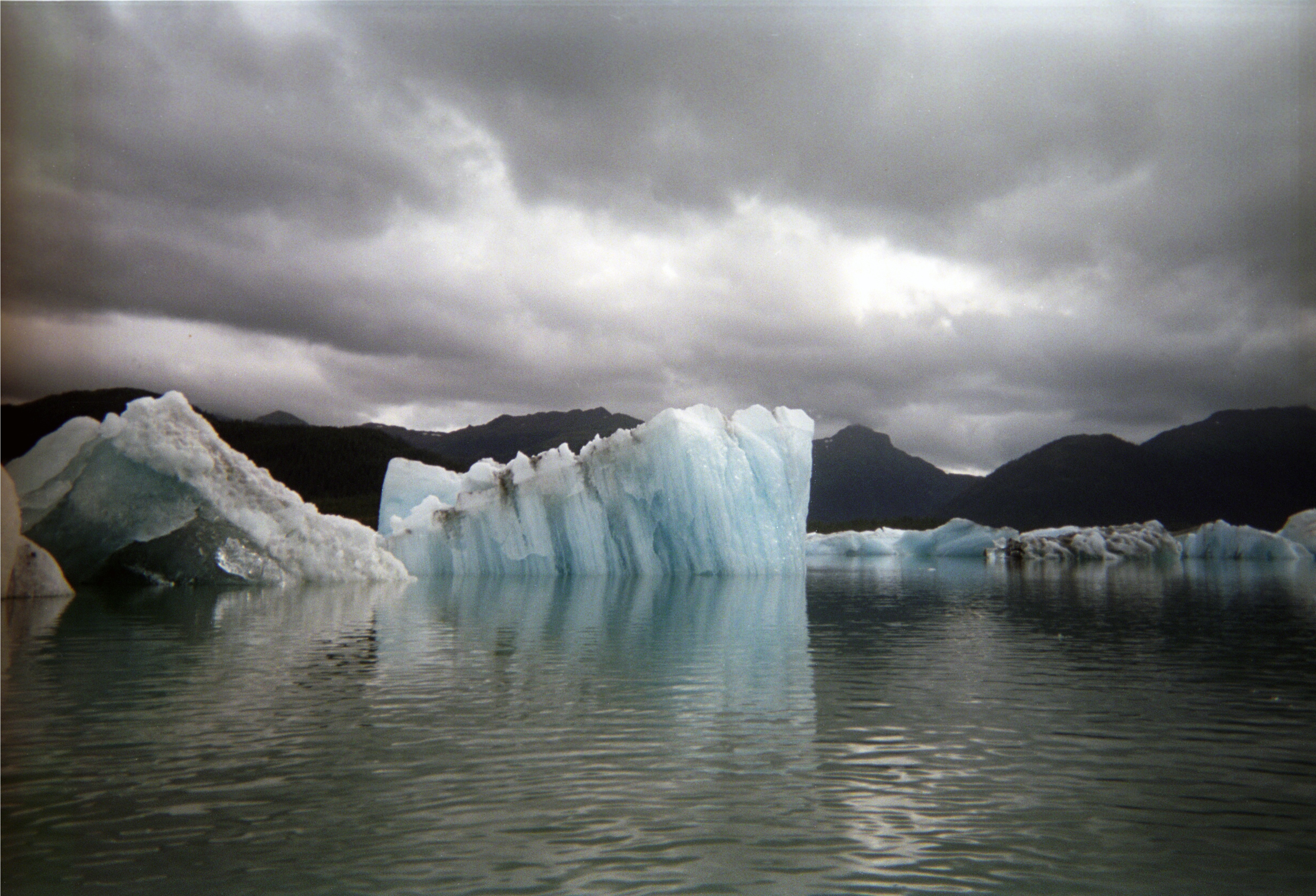
What were your first impressions as you reached the Arctic by boat?

It was much different than I expected. I knew it would be isolated and desolate, but it was like the backside of the moon. There was no plant life; we went two months without seeing another boat or another person, and every time anyone went ashore onto the ice, two of us had to go together and we had to have guns.

Describe the environment.

The midnight sun was ethereal with a bluish cast to it. Human faces don’t look pink and healthy—they look blue and gaunt. It is really powerful. The wildlife was stunning.

Describe a typical day.

You wake up four different times and are always busy. You stand watch, are briefed as to what is going on, check the engine room, download the ice charts, weather charts, keep your eyes open for anything—a rogue piece of ice or whales getting ready to jump

What was typical progress and how much fuel did you use?

A good day would be 200 miles and we’d travel between 7.5 and 8 knots. The tank holds 2,200 gallons of fuel and we used a little less than 8,000 gallons, total. We got fuel in Greenland, and topped off the tank in Nome and in Sitka, and that lasted us to Seattle.

What were some of the more interesting shots you filmed?

It was all really stunning. And the underwater footage is incredible. Everyone has seen life above the ice. Seeing the hull of the boat coming through the ice is amazing.

You were stuck on the ice for several days. What happened?

That was horrific. Our options dwindled very slowly and inexorably. We had been anchored off of a small island downloading the ice charts, and saw a lead open in the ice. The next chart came down, and the lead was even bigger, so we went for it. We were halfway in it, when we saw a white wall coming toward us. The wind doesn’t drive the ice, the currents do, and the currents had changed.

On the first day we were trapped, in 18 hours we moved 17 miles. The next day we made two miles in five hours. I went to bed thinking the next thing I was going to hear was the crunch of the ice decimating the boat. But four hours later I woke up, and we were seven miles off the coast, had a small lead, and we pushed and pushed and began to work our way out of it. 

Icebergs show up on the radar. Theobald and crew were trapped in the ice when changing currents closed leads (openings in the ice) that previously looked open. Photo: Northwest Passage Film

What were the potential consequences of being trapped?

We couldn’t move. It was the first time in my life I had ever been without an option. We felt hopeless. We were trapped, caught, not moving. In the worst-case scenario, we would have had to abandon the ship and make our way to the closest civilization over ice.

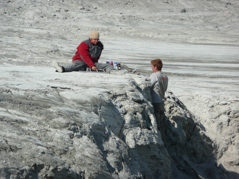
Did you film during this crisis?

With great precaution we went out onto the ice and got some magnificent footage of the boat trapped. We also dove under the boat and locked in some great shots.

What was the most dangerous aspect of being trapped?

The ice felt like an avalanche in very slow motion, the compasses were all deviating because we were so far north, so we had to rely on GPS to navigate. We dropped anchor on the ice floe, and so we would move with the ice, but the current changed yet again and at one point, instead of being a mile and a half off shore, we were a quarter mile off shore. We were either going to wreck on the rocks or on the ice.

How did you get out of the situation?

Luck. The current changed again, and then we saw a small opening and we went for it as aggressively as we could. When we were finally liberated, there weren’t whoops of joy or loud yahoos. Everyone was so depleted.

You said you have an interest and eagerness to support or inspire the educational/scientific communities with your footage and experiences. What are some ways you envision doing that?

The goal for any documentary is for someone to sit there at the end and say, “I never knew that.” I want to open their eyes a little bit, and if I can develop partnerships with any scientists or educational outlets to use some of my footage to accomplish that, then that would be good.

When will we see the documentary?

It will take about three months to log all the footage, and by the beginning of the summer we’ll have a good rough cut. A lot of people have expressed an interest in seeing the footage, so right now I am working on creating a good five-minute teaser.

Much of your crew was related to you.

Yep, it didn’t start off as a family trip, but my crew included my stepdaughter, Dominique Tanton, 28, and stepson, Chaunce Tanton, 32, and their half brother and my son Sefton Theobald, 22.

This expedition pulled the family back together in a way that was totally unexpected.

When did you decide to make this expedition a reality?

In 2007. I was out to dinner with friends in New York and was asked if there was a trip I hadn’t yet done as a filmmaker, and the words “Northwest Passage” flew out of my mouth and were there on the table. And it was realistic, particularly with the ice opening up that summer. I had a boat, I had crew people in mind, and—this was before the economy fell apart—I had potential sponsors lined up to underwrite it.

Who were your sponsors?

Nordhavn, the boat manufacturer (and I owned a Nordhavn) signed on right away. But last September (2008) the economy began to crumble and they and my other sponsors had to pull out. I completely understood. They didn’t have the money.

How did you pay for the expedition, and what was your budget?

I used the proceeds from the sale of my home several years earlier. It was completely self-funded and cost me about $300,000.

What are your final thoughts on the expedition?

It was an astounding trip. I hope that whatever happens in the future with the Northwest Passage, we all use our brains about it. It truly is one of the last wild adventures.


Greenland’s Summit Camp in the Winter

November 23, 2009

Summit Camp science technician Katie Koster hauls 130-lb. fuel tanks in preparation for winter in Greenland. Koster is one of five people (four Polar Field Services, one NOAA) holding down the fort at Summit Camp. Photo: Andy Clarke

The biggest challenge to spending a winter at Greenland’s Summit Station isn’t the isolation, the dark, or even the cold. Rather the largest difficulty with living at and operating the station through the Winter Solstice and beyond is willing one’s fingers and brain to fire on all cylinders working outside in temperatures that range between -25ºC and -70ºC.

Life In The Far North

Check out the 2007 POLAR-PALOOZA video above with PFS’ Kathy Young for a good overview of life at Summit Camp during the summer. Although it was shot two years ago (before CH2M HILL purchased VECO), daily life remains remarkably similar.  Remove most of the people, the sunlight and knock the temperatures into the negative 20s and below, and you can imagine Summit in the winter.

This season’s five-person crew arrived Nov. 4 to operate Summit Station through the winter months, taking over for the five-person crew that tended the station after it closed for the season in late August. On Nov. 14, the team observed the last official sunrise/sunset until January 29, 2010.  They inhabit winterized buildings, share meal and housekeeping duties, and have about 300 movies to watch during downtime.

Game and movie room at Summit Camp's Big House. Photo: Karl Newyear

Clearly the team is there for much more than downtime. As manager Karl Newyear notes, they come for the self-reliance and the sense of adventure. “It’s intriguing to me that humans can adapt to places as inhospitable to life as the top of the icecap,” he says.  But mostly they come because they’ve been hired to maintain the infrastructure needed to support almost 30 year-round science experiments housed at the station.

Meet The Crew

Mindng the Summit. The crew from left to right: Glenn Grant, Shane Brazzel, Karl Newyear (front), Katie Koster, Mark Melcon (aka Commander).

Fortunately, members of the experienced winter crew are well-suited to extreme temperatures. This rugged and hearty team brings collective polar experience to the job. Camp Manager Newyear spent 10 years as a marine projects coordinator in Antarctica. A logistics specialist with a Ph.D. in oceanography, Newyear lives in Parker, CO., when he’s not on ice.

"Business casual" means something different in Greenland. Karl Newyear in front of Summit Camp's Green House.

Mechanic Shane Brazzel comes to Greenland from Antarctica’s McMurdo Station, where he was a heavy equipment mechanic and on the construction crew. The dirt-bike-loving Californian works nine hours a day, seven days a week checking the generators, monitoring mechanical systems, operating and maintaining station vehicles (snowmobiles, Cat 933 track-loader, and Cat D-6 tractor), and making water by dumping buckets of snow into the melter.

Mark Melcon (aka Commander) is a polar legend with about 20 deployments to Antarctica, eight to Greenland, and one to Alaska. After spending last summer on the Summit construction crew, he’s back for the winter and maintaining his own personal brutal work schedule: rise at 4 a.m., begin working around 7:30 and average about nine hours a day.

Glenn Grant, science technician, is in Greenland for the first time after spending more than a decade in Antarctica. Since 1995, he has worked at Antarctic research stations at Palmer, McMurdo, and the South Pole, on both south polar research ships (Nathanel B. Palmer, Laurence M. Gould), and logged six winter seasons. When not in a polar region, he maintains residence in Port Townsend, WA, and works on other science projects, including some at the National Center for Atmospheric Research in Boulder, CO, the Atlantic Undersea Test and Evaluation Center, in the Bahamas, and aboard the NOAA research vessel RAINIER.

Glenn launches a weather balloon, one of the many responsibilities of the winter crew at Summit. Photo: Karl Newyear

Rounding out the team is NOAA science technician Katie Koster, who also spent her early fall working at Summit, thus adding an element of continuity and familiarity between the Phase I crew (which has scattered around the globe) and the current crew. Katie, a meteorologist, has observed weather at New Hampshire’s Mount Washington as well as at the South Pole (and she’s also a seasoned Summiteer, having worked the 2008 summer and phase I winter as well). An accomplished cyclist and runner, Katie also has been an ice hockey referee.

General Lifestyle

All in a day's work: Katie and Glenn head off to monitor science experiments for absent researchers. Photo: Karl Newyear

All adventurers, the self-selective staff in the far north say spending the winter in Greenland gives them the unique experiences of living in clean air without light pollution, having unrivaled views of the stars and aurora borealis.

With Internet access and routine communication with Polar Field Service staff  as well as colleagues in Kangerlussuaq, they aren’t entirely isolated. And despite the cold, they spend much of their time outside doing physical work. Those seeking an extra adrenaline rush can use one of the three spinning cycles, the rowing machine, free weights, or the rock-climbing practice board, and staffers have been known to strap cross-country skis (or snow kites) on.

Wind-affected snow surrounds Summit Camp in the winter. Photo: Bill McCormick

About Summit Camp

Located at the peak of the Greenland ice cap at 72°34’44.10″N 38°27’34.56″W. Summit is a scientific research station sponsored by the National Science Foundation, operated by CH2M Hill Polar Services (CPS) with research guidance from the Summit Science Coordination Office.


In the Media

November 19, 2009

Documentary Filmmaker Completes Northwest Passage Trip


The M/V Bagan cruises past icebergs as she makes her way through The Storied Northwest Passage. Documentarian Sprague Theobald and Hole in the Wall Productions will bring us stories from their 5-month cruise. Photo: © HITW Productions; http://northwestpassagefilm.com

Filmmaker Sprague Theobald completed a trip through the Northwest Passage, arriving in Ketchikan, AK, Oct. 27 on a 57-foot Nordhavn power boat, reports the Fairbanks Daily News Miner. Theobald and his crew, which included was his son, Sefton Theobald; master diver Greg Deascentis; and cameraman Ulli Bonnekamp, among others, departed Newport, R. I., on June 16. During the journey, the team was hit by an ice floe that trapped their boat in the ice for days. “It was worth the risk, but I would not do it again,” Theobold told Yachting Magazine. “We have yet to talk publicly about the more terrifying moments of the trip.” During the voyage, he interviewed Inuit elders, other sailors attempting the passage, politicians, and conservationists as he collected material for a full-length documentary, Braving the Northwest Passage, forthcoming. Learn more about the adventure at his blog.

Emmy-winning filmmaker Sprague Theobald eyes sea ice from the bow of the Began. Photo: © HITW Productions (http://northwestpassagefilm.com). To visit the Web site, click on the picture.

 
Arctic Commercial Fishing Limits To Go Into Effect Dec. 3

The Associated Press reports that strict commercial fishing limits in the Arctic will go into effect Dec. 3, following a push from the National Oceanic and Atmospheric Administration to develop a plan to regulate commercial fishing in the Arctic in the wake of melting sea ice. The restrictions prohibit industrial fishing in nearly 200,000 square miles of U.S. waters in the Beaufort and Chukchi seas.


Much Arctic Warming Linked To Sea Ice, Cloud Cover Changes

Icebergs in Columbia Bay, Alaska, are representative of ice bodies impacted by Arctic warming. Photo: University Corporation for Atmospheric Research

A study published in the Nov., 2009, issue of the journal Geophysical Research Letters asserts that much of the dramatic change documented in the Arctic over the past 20 years correlates with changes in sea ice concentration and cloud cover. Lead author Yinghui Liu (Cooperative Institute for Meteorological Satellite Studies, University of Wisconsin-Madison, Madison, Wisconsin) writes that sea ice loss in the Chukchi and Beaufort seas in the fall account for significant surface warming. Specifically, the researchers analyze the influence of trends in sea ice concentration and cloud cover on surface temperature in the Arctic from 1982 to 2004. They find that sea ice concentration and cloud cover play a large role in observed temperature trends. For instance, their analysis shows that surface warming associated with sea ice accounts for more than 0.9 degrees Celsius (1.62 degrees Fahrenheit) per decade of the observed 1.1 degrees Celsius (about 2 degrees Fahrenheit) per decade warming trend in autumn. In addition, in winter, cloud cover changes explain 0.91 degrees Celsius (1.64 degrees Fahrenheit) of the 1.2 degrees Celsius (2.16 degrees Fahrenheit) per decade surface temperature cooling, and in spring, 0.55 degrees Celsius (0.99 degrees Fahrenheit) per decade of the total 1 degree Celsius (1.8 degree Fahrenheit) per decade warming is attributable to cloud cover. The authors note that their model provides insight into the causes of recent temperature trends and could be extended to study the influences of other parameters such as sea ice thickness.


Study Links Climate Change to California Drought

U.S. News & World Report publishes a story that the centuries-long droughts experienced by the state of California over the past 20,000 years coincided with thawing Arctic Ice Caps. The research, published online in the journal Earth and Planetary Science Letters  by UC Davis doctoral student Jessica Oster and geology professor Isabel Montanez, present evidence from analysis of stalagmites from Moaning Cavern and Black Chasm in the central Sierra Nevada. The authors compared climate records from Greenland with the climate records from the stalagmites. At the end of the last ice age about 15,000 years ago, California became much drier. When Arctic records indicate a cooling period about 13,000 years ago, the data show California experienced wetter weather. The scientists don’t offer an explanation for the relationship between Arctic temperatures and California’s precipitation. But the article says that climate models developed by others suggest that “When Arctic sea ice disappears, the jet stream—high-altitude winds with a profound influence on climate—shifts north, moving precipitation away from California.”

 
And Finally…

The Copenhagen Climate Conference is less than a month away (December 6 – 18).


Gifts From The Ancestors

November 18, 2009

Okvik human head carved from Walrus ivory, Princeton University Art Museum; The Lloyd E. Cotsen, Class of 1950, Eskimo Bone and Ivory Carving Collection. Photo: Bruce M. White

For the first time since the late 1980s, a museum exhibition of ivory artifacts and other remnants from the ancient cultures of the Bering Strait is on display at the Princeton Art Museum, in Princeton, New Jersey. “Gifts from The Ancestors” opened Oct. 3 at the University’s art museum with an impressive collection of archaeological art collected over the past millennia from the Bering Strait Region. These objects served as tools to sustain the subsistence hunting lifestyle of the native people, and the exhibition aims to celebrate the artistry and ingenuity of the culture, said Bryan Just, curator of the exhibition.

“The exhibition brings an awareness of the region and its history,” said Just. “It also provided an opportunity to bring a number of Alaska natives to Princeton and involve them in a whole series of opening weekends. They had the chance to see how we’re presenting their ancestry.”

The majority of the objects are carved from walrus ivory and were originally unearthed from archaeological sites along the “Old Bering Sea,” which includes areas of the Chukchi Peninsula in Russia, northwest Alaska, and St. Lawrence Island. With funding from the National Endowment for the Humanities, Just and guest curators William Fitzhugh, National Museum of Natural History, and Julie Hollowell, cultural anthropologist, arranged for loans from museums and private collections.

Harpoon socket piece carved as a predator, Walrus ivory, Princeton University Art Museum Bequest of John B. Elliott, Class of 1951. Photo: Bruce M. White

The artifacts date from roughly 100 A.D. to 1600 and most are ornately carved with intricate designs endowed with various meanings. At once beautiful and utilitarian, the tools that allowed the natives to hunt whales from kayaks also evoked the spirits and testified to the communities’ faith, said Just.

“Lacking a written tradition around the time of the material it is difficult to know with any certainty if it was considered art,” said Just. “Since there is such beautiful carving on utilitarian objects, it suggests that the division between function and form is not necessarily relevant for this material.”

Much of the engraving on each object was believed to imbue it with the power of a spirit. Oral tradition suggests that this effort improved the efficacy of, say, a harpoon. Walking through the exhibit evokes the imagination, drawing the viewer in close to the objects, many of which measure only several inches tall. Many have specific and unique additions—little hooks and swivels that seem quite practical and functional. And many are polymorphic or polyiconic, said Just, meaning that when observed from different perspectives, an object can take on many forms.

“That layering of imagery is a fascinating thing and shows these objects are tactile works of art,” he said. “They are meant to be handled.”

Punuk or Thule Comb, Walrus Ivory, Princeton University Art Museum; The Lloyd E. Cotsen, Class of 1950, Eskimo Bone and Ivory Carving Collection. Photo: Bruce M. White

Unfortunately, the museum cannot allow visitors to touch the ancient artifacts, so the curators attempted to present them in a number of different orientations.

Their success is evident in the attention and number of visitors the exhibition has received. Courses at the university are incorporating it into classes, and local school children are taking field trips to the museum. The New York Times has written about the exhibition, as have other media outlets.

The exhibit addresses the issue of repatriation, and the Web site offers a detailed explanation of U.S. legislation that provides special protections for Native American sites. For example, the Native American Graves Protection and Repatriation Act (NAGPRA), passed by the federal government in 1990, provides a process for museums and Federal agencies to return certain Native American cultural items — human remains, funerary objects, sacred objects, or objects of cultural patrimony — to lineal descendants, culturally affiliated Indian tribes, Alaska native clans or villages, and Native Hawaiian organizations.

And while art seems to belong to the humanities, there is overlap with scientific research. Polar Field Services supports several National Science Foundation-funded studies that make the connection (see this recent post on Aaron Fox’s music repatriation effort, for example). Connections between art and science—particularly at this moment in time of globalization and climate change—can be found in increased awareness of northern cultures, said Just.

“This art incorporates a sensitivity to beauty, and a deep and profound respect of the reciprocal nature of a people’s place in an ecosystem,” he said.


The Arctic Report Card – Are We Passing?

November 16, 2009
By Marcy Davis

A small bird rests atop of bit of melting ice near Ilulissat, Greenland. All photos: Ed Stockard


And you think your students’ grades are dismal?

NOAA recently released the 2009 Arctic Report Card, an annual peer-reviewed summary on the state-of-the-Arctic compiled by an international group of arctic experts and scientists.  This year’s headline reads, “Warming of the Arctic continues to be widespread, and in some cases, dramatic. Linkages between air, land, sea, and biology are evident.”

The report, now in its third year, seeks to communicate up-to-date scientific information to scientists, students, teachers, and policy-makers. Concise descriptions of changes in atmosphere, sea ice, ocean, land, and biological markers are presented with descriptive photographs, graphics, and relevant references. The Greenland Ice Sheet receives special consideration as a sensitive indicator of arctic climate warming.

This iceberg in Disko Bay probably once belonged to Greenland's mighty Jakobshavn Glacier.

Some Arctic Report Card highlights include:

  • Melting multi-year sea ice is being replaced by first-year sea ice
  • Unprecedented amounts of fresh water in the upper layer of the Arctic Ocean from melting sea ice
  • Declining numbers in many caribou and reindeer herds
  • Record-setting summer temperatures and ice sheet loss in Greenland
  • Changes in atmospheric circulation due to heating of the ocean surface
  • More discharge from Siberian rivers
  • Less snow in North America

A caribou near Kangerlussuaq, Greenland.

Can we do better next year?

 View the Arctic Report Card:  Update for 2009 http://www.arctic.noaa.gov/reportcard/index.html


Twenty Years After The Oil Spill

November 13, 2009
Impacts of The Exxon Valdez Tanker and The Largest Oil Spill In History

Oil spills from the Exxon Valdez on the morning of March 24, 1989, after the vessel ran aground on Bligh Reef in Prince William Sound. Photo: Erik Hill/Anchorage Daily News

Studying the Effects of a Technical Disaster

 When Dr. Duane Gill (Oklahoma State University) traveled to Cordova, Alaska, in 1989 following the catastrophic incident of the tanker vessel Exxon Valdez running aground on Bligh Reef in Prince William Sound (PWS) and spilling 11 million gallons of crude oil, he could not have anticipated he’d stumbled upon his life’s work. A professor of sociology, Gill spent the next two decades documenting sociological impacts of the spill on the lives of Cordova residents. From their decimated fishery to an extended legal battle over remuneration that rose to the Supreme Court, he, Dr. Steve Picou and a research team including Maurie Cohen, Liesel Ritchie, and Kati Arata dove into the spill’s aftermath in what he calls a “20-year odyssey” studying the impacts of the largest oil spill in history and its devastating impacts.

2008:  Supreme Court Mandates A (Much Reduced) Punitive Damage of $500 million

In what may be his final assessment of the community, Gill is heading north 20 years after the spill with funding from the National Science Foundation for a research project to document how a 2008 decision by the U.S. Supreme Court ordering Exxon to pay $500 million in punitive damages affects the community. Exxon was originally ordered to pay $5 billion in punitive damages to 33,000 plaintiffs in a 1994 jury trial, but the Court implemented a one-to-one ratio of punitive damages to actual damages reducing the award to one-tenth of the original amount. Even with an additional $500 million in interest that Exxon has been ordered to pay, the total award does not cover economic, social and cultural losses experienced by many survivors of this disaster.

The spill eviscerated much of the wildlife and decimated fisheries. This devastated the local economy, which was based on natural resources. Photo: Wikipedia

In their latest project, Gill, Picou, and Ritchie will study impacts of the litigation decision and subsequent disbursement of money on individuals, groups and the Cordova community. Gill and Ritchie will travel to Alaska in mid-November to continue a panel study of commercial fishermen and Alaska Natives that began in 2001. A panel study collects data from the same person at different points in time; Gill hopes to survey as many of the original participants as he can. They will return to Cordova over the next two years to conduct intensive interviews as a continuation of a qualitative panel study initiated by Ritchie in 2002. Finally, Picou will oversee a telephone survey of the Cordova community during the last year of the three-year project. Gill expects to wrap up the study in 2012.

Community Reaction

 “Last year, when the ruling came out, people were shocked, devastated, and angered,” said Gill. “I heard a lot of cussing after the decision was announced. There was a sense of betrayal and loss of faith in the justice system.”

One Cordova resident confided to Gill that he “cannot say the pledge of allegiance anymore because the last line says, ‘justice for all,’ and that’s a sham.”

Gill said the bitter disappointment he witnessed last year, immediately after the ruling was announced, was emotionally tough. Over the decades he has earned the trust and respect of those he studies. And the academic value of his research allows him and his colleagues to maintain professionalism while having empathy for their subjects.

“Do I get emotionally involved?” he asked. “Of course. I have a heart. We maintain professionalism in the field and we don’t compromise that, but at the same time we’re human and there is empathy for the people and community.”

Ongoing Research on the Impacts of the Oil Spill: Ecological Damage, Psychological Distress


Crews clean up the oil spill on a beach following the accident with the Exxon Valdez tanker. Photo: Wikipedia

Since the spill, which occurred March 24, 1989, Gill and the research team have documented impacts of the environmental damage to the community. The research team examined how Cordova and groups like commercial fishermen and Alaska Natives are tied to renewable resources such as fish and how damages to these resources disrupted the local economy, as well as cultural activities and social networks. Much of the social disruption and psychological stress observed by the research team in the first few years after the spill were related to damaged resources that were slow to recover—20 years after the spill, only nine of 22 species damaged by the spill have completely recovered. In the mid-1990s, as Exxon appealed court rulings on punitive damages, Gill observed lingering disruption and psychological stress within the community.

“There was chronic distress because things weren’t resolved,” said Gill. “A lot of the stress was not only due to natural resource damages, but also to the unresolved litigation.”

Prolonged litigation is stressful, he said. Residents accustomed to a subsistence- and renewable resource-based lifestyle had to adjust to dealing with attorneys, a complex legal system, and a giant corporation with seemingly unlimited resources.

“There has been prolonged uncertainty as well as a sense that this case should have been resolved,” he said. “In addition, these people suffered a lot of damage, especially with the collapse of the herring fishery. The actual damage award was calculated in 1994 and does not cover the losses these people have continued to experience.”

Mental Health Impacts

 In the mid-1990s, the community invited Gill and his colleague Steve Picou to devise a mental health program focused on coping with technological disasters. Recognizing that a disaster like this oil spill had implications that reached far beyond the ordinary disruptions to services and jobs, the two social scientists aimed to address the less tangible impacts of the disaster. For instance, they noted “disruption of family structure and unity, domestic violence, depression, alcoholism, drug abuse, and psychological impairment.” At the community’s request, they developed a guidebook on how to cope with technological disasters.

“What began as an academic study on community impacts of a technical disaster evolved into a practical application to help (the guidebook), and later to a specific focus on litigation impacts in 2000,” said Gill. “The community expected a decision and waited for years. Instead of a decision, the case just got passed back and forth between the courts.”

Settlement Expectations

Initially, Gill and his colleagues expected the punitive damage award would have an overwhelming impact on the community. When residents were expecting payouts of billions of dollars, the research team anticipated an economic boom that would affect at least 40 percent of the households in the community and lead to a “money spill.”

“A lot of the fishermen who weren’t able to fish worked for Exxon in 1989, and some became known as ‘spillionaires,'” said Gill. Some felt those who worked for Exxon had sold out, and that they were enriching themselves as others suffered. There was concern that a similar scenario would be repeated with the punitive damage award disbursement. With the drastic reduction in punitive damages, the impacts are hypothesized to be different than previously expected.

Reluctant Resignation


Twenty years after the spill, the obvious damage has been cleaned up, but mistrust of the government and corporations remains and will likely linger, says Gill. Photo: Erik Hill/Anchorage Daily News

Now, with last year’s Supreme Court decision, Gill said this current research project may be the last. Twenty years after 11 million gallons of oil spilled into Prince William Sound, there may finally be closure. Gill said he expects to find evidence of “reluctant resignation.”

“The attorneys for the community see the Supreme Court decision as a loss,” he said. “I expect the stress and the disruption that we have measured over the past several years will begin to decline. I think the community will begin to arrive at some semblance of normalcy. They can begin to put this behind them.”

Granted, the Exxon Valdez oil spill will not completely be resolved until the ecosystem recovers, but from a sociological perspective, Gill anticipates the disruption and stress to dissipate. In its place, though, feelings of betrayal and distrust will likely linger.

“I think we will find a persistent loss and lack of trust in basic social institutions such as the court system, loss of trust in state and federal government, lack of trust in major corporations,” he said. “That equates into a loss of social capital that is based upon issues and networks of trust and reciprocity. This disaster has changed their worldview. Many people in Cordova believe they cannot depend upon things they used to depend upon.”

“Most of the people we have talked to believe the ecosystem will not recover in their lifetime,” Gill said. “For many, the only way the disaster will end is when they die.”


Well, it COULD be the Arctic!

November 12, 2009
PalmerStationNASA

Click on the image for a larger view. Credit: NASA/John Arvesen

At Palmer Station, Antarctica, NSF-funded US research program participants used their bright red parkas to send ground-to-air greetings to scientists and the flight crew aboard NASA’s DC-8 flying science laboratory as it flew over the station during Operation Ice Bridge. Operation Ice Bridge is a study of polar ice sheets, sea ice and glacial recession.

The missions help bridge the data gap between ICESat-I (which will likely end this year) and the launch of ICESat-II (around 2014). Satellite information provided by the ICESat program help scientists understand and monitor changes in the planet’s polar icescapes.

Operation Ice Bridge flew over Greenland  last April, as it has most years since 1991 (William Krabill, NASA Wallops, leads the arctic work).  You can learn more about the mission, and get in the plane with the NASA scientists, via the video posted to the Operation Ice Bridge Greenland page.   

Want more? Visit the Ice Bridge blog! 

Update: Our friend, the expeditionary artist Maria Coryell-Martin, writes about Operation Ice Bridge on her blog. Her father, Seelye Martin (U Washington), is conducting research on the flying laboratory. “When I was young, he embarked on several cruises to the Arctic and shared stories of the ice, animals, and darkness” she recalls. “I remember talking through radio-patch phone calls and at home, his two large parkas fill the hall closet.” Maria says her interest in painting ice springs largely from her father. View her work on her Web site.


NASAIceBridgeLogo


Veterans Day

November 11, 2009

We thank our friends in the New York Air National Guard 109th Airlift Wing for their service to our country.

A skibird on snow at NEEM, Greenland. Photo: Ed Stockard

The 109th 'skibird' on snow at NEEM drill camp in Greenland. Photo: Ed Stockard

On the sea-ice runway at McMurdo Station, Antarctica, where the unit supports the NSF's antarctic research. Photo courtesy ANG 109th

Directing traffic on the sea-ice runway at McMurdo Station, Antarctica. Photo courtesy 109th ANG


090915-F-6576G-002

Master Sgt. Ed Holub is welcomed home from a tour in Afghanistan by his children September 15th. Photo courtesy ANG 109th


Retracing Alaskan Genealogical Lineage through DNA studies

November 10, 2009

By Marcy Davis

P1010127

An overview of the Nuvuk site and archaeological excavations at Pt. Barrow, Alaska. Photo: Dennis O'Rourke

Researchers believe that humans probably arrived in the North American Arctic toward the end of or following the last Ice Age, about 12,000 years ago, via northern land bridges now covered by shallow seas (the Bering Sea is one example). These nomadic peoples likely followed large herds of caribou, muskox, bison, and mammoth.

Anthropological geneticist Dennis O’Rourke (University of Utah) is fascinated not only by how successfully people acclimatized to life in harsh high-latitude climates, but also how they spread out and settled in the Arctic. In an attempt to get at the details, O’Rourke and geneticist Geoff Hayes (Northwestern University) are giving new meaning to the age-old question “where do we come from,” at least for Iñupiat people of Barrow. O’Rourke and Hayes’ three-year project aims to determine ancestry and lineage in Alaska’s northwest Arctic and North Slope and in the circum-Arctic region.

Deoxyribonucleic acid (DNA) contains genetic information and instructions for cell and protein construction. We each obtain certain DNA components from our mothers and others from our fathers. O’Rourke and Hayes hope to track settlement patterns throughout the Arctic by comparing certain parts of the DNA contributed from mothers and certain parts from fathers in ancient and contemporary populations.

Collecting DNA from Barrow residents is relatively easy. Volunteers rinse with a special mouthwash and spit into a test tube. Their DNA can easily be teased out of their saliva back in Hayes’ lab. Obtaining DNA samples from residents of nearby Nuvuk, however, is a little more involved.

Located at the very end of Point Barrow, Nuvuk is an ancient village site. Archaeologists believe Nuvuk was occupied by the Thule culture, the Iñupiat ancestors, for more than 1000 years until the 1930’s, when it was abandoned. As a result, the only current residents of Nuvuk are found in the cemetery—an old burial ground that is slowly being washed away as the coastline gives way to shifting point sands and beach erosion. An effort has been ongoing for about 10 years to document, stabilize, rescue and relocate the burial sites; this effort also has allowed scientists to study the artifacts uncovered at the sites for information about the ancient people.

DSC00578

Justin Tackney, PhD student at the University of Utah, works at a sterile workstation on ancient DNA extractions from human remains. The sterile nature of the lab, the workstation, and the 'clean garb' Justin wears, prevents contamination of the ancient samples with modern DNA.

The Barrow community supports and is actively involved in the Nuvuk cemetery effort. “The local community felt this was the right thing to do and gave us permission to do the Nuvuk studies,” O’Rourke explains. “It’s wonderful that they are so helpful and interested in using these approaches to learning and understanding about where their ancestors came from.”

Anne Jensen, an archaeologist and UIC Science Director in Barrow, is working to locate, exhume, and reinter those buried at Nuvuk. O’Rourke and his students cooperate with Jensen, who also involves local high schoolers in the research, as part of a larger collaboration that hopes to trace the heritage of the Nuvuk people.

DNA degrades over time, but Barrow’s cold climate helps preserve DNA in the Thule buried at Nuvuk whose remains can be more than 1000 years old. Ancient DNA samples are easily contaminated, however, so O’Rourke’s team works closely with Jensen to collect very small samples, no larger than a small rib. As soon as specimens are unearthed, researchers cover and then place them in a sterile container.

IMG_1411

Justin Tackney prepares to collect samples for ancient DNA analysis from Nuvuk, Pt. Barrow, AK. Photo: Dennis O'Rourke

The samples are stored in a freezer at Barrow until they are flown back to a clean lab in Salt Lake City. There, scientists chemically treat the samples to release specific DNA sequences. By comparing sequences obtained from the Nuvuk population to other ancient populations along the North Slope, southern Alaska, eastern Canada, and Greenland–and to contemporary populations at Barrow and around the Arctic–O’Rourke and Hayes can determine not only who’s related to whom and how closely related people are in time and space, but how people moved around and settled in the Arctic region.


Looking Back to Look Ahead

November 9, 2009

An Air Greenland helicopter arrives to return Jason Briner and his field crew to town after a month in the field studying the rocks and lakes around the Jakobshavn Isbrae. Photo: Jason Briner

As climate scientists attempt to forecast how increases in atmospheric temperatures expedite the melting of polar ice sheets, a team of paleoclimatologists is searching back in time for important clues on the effects of previous climate disruptions. Specifically, the team, led by Dr. Jason Briner (State University of New York, Buffalo), is studying Greenland’s Jakobshavn Isbrae to understand how climate changes during the Little Ice Age and Holocene thermal maximum—a time span of roughly 10,000 to 100 years ago—impacted the glacier’s behavior. Given that the most comprehensive data on the glacier span only about two to three decades, reconstructing the Jakobshavn’s response to climate change over a period of thousands of years will yield insights into the relationship between warming temperatures and glacial trends, said Briner.

“The intent of paleoclimatology is to see what the earth systems are capable of doing in longer time periods and in different climate regimes,” said Briner. “By looking in the past, we have the ability to know what happened when it was 5 to 10 degrees colder or warmer. We are trying to make our research relevant in the context of modern climate changes so we might better understand what might happen in the future.”

Working on the Jakobshavn also provides a unique opportunity to do paleo work on an existing glacier, said Briner.

Jakobshavn Isbrae: The World’s Fastest Moving Glacier

Jakobshavn Isbrae is considered the world’s fastest moving glacier. According to a recent article in the Financial Times, the Jakobshavn Isbrae is perhaps the fastest moving glacier in the world. It drains roughly 6.5 percent of the Greenland ice sheet, and has been documented to be moving at 13 km per year and pouring about 40 km3 per year of ice into the fjord.

In the past two years, Briner and his team conducted a National Science Foundation-supported pilot study to demonstrate the utility of analyzing the glacier’s past. Concentrating on the Holocene period, which began about 12,000 years ago, when average temperatures were about 3 degrees Celsius warmer than they are today, they attempted to identify more precise temperature ranges as well as to understand the glacier’s activity. They also collected information from the Little Ice Age, which followed the middle Holocene warm period and marked a cooling of the earth’s climate from about 600 to 100 years ago.

SUNY-Buffalo undergraduate student William Phlipps and graduate student Shanna Losee take core samples from a big pile of mud that formerly was a lake during the Little Ice Age. As the ice sheet advanced during the Little Ice Age, it blocked a river and created a lake. Once the lake was there, the river valley was buried by silty lake sediments. In the late 1980s, the lake drained out completely because the ice sheet (the lake's dam) retreated, and all the water spilled out. Photo: Jason Briner

Their data came from isotope analysis and radiocarbon dating of lake sediment, as well from three-dimensional maps created using historical photos and an assessment of the insect remains within their lake sediment samples. Although the team’s research focuses on the glacier itself, their detective work took place on the surrounding rocks and in the many lakes on the glacial moraine.

“We work where the ice was, not where it is,” said Briner. “Our geologic record comes from the landscape.”

Will Phlipps and Nicolas Young, PhD student, SUNY-Buffalo, hike along the crest of a moraine deposited during the Little Ice Age. In the distance is the iceberg-choked icefjord, which was occupied by the Jakobshavn ice stream during the Little Ice Age. The ice margin is now about 20 km away. Photo: Jason Briner

Lakes Rich With History

These lakes serve as conservatories of glacial debris, which drained into them when the Jakobshavn melted and retreated over time. Briner and his team study sediment cores from the lakes to date the contacts, which is how they confirmed the glacier advanced during the Little Ice Age.

“Until the Little Ice Age, the lakes had no glacial meltwater input,” said Briner. “The ice margin advanced during the Little Ice Age close to pre-existing lakes, but not over them.  In fact, it advanced just barely close enough that it spilled its melt water into the lake basin and ultimately the silt particles in the ice sheet melt water were deposited in the lake, which, prior to that, just had the organic sediments. When the glacier retreated, its margin receded back out of the lake’s drainage basin.”

Shanna Losee, Nicolas Young, and Will Phlipps on a coring platform on one of the lakes in the study area. Photo: Jason Briner

Putting the Puzzle Together

The team aims to reconstruct the climate and establish a more specific temperature record that spans the Holocene period. Currently scientists have a broad understanding of the average temperatures during the Holocene, but those temperatures varied significantly depending on altitude and location, said Briner.

“We are trying to get a record from our site and quantify the changes in ecology to get a local temperature record to see if it syncs with what the glacier was doing,” he said

The research at Jakobshavn is similar to research Briner and fellow scientists recently completed at the Sam Ford Fjord in Canada’s Baffin Island. Similar climate reconstruction efforts found that 9,500 years ago, the fjord’s kilometer-thick glacier melted in a “geologic instant” during a climate-warming period. Like the glacier in Sam Ford, Jakobshavn is sitting in a similarly deep fjord. Briner said the Baffin Island work revealed the significance of glaciers that lie in very deep water.

“When glaciers that calve retreat into deeper water, that promotes further retreat,” he said. “And that amplifies the retreat rate.”

The Jakobshavn is one of these glaciers; the calving front is in only 800 meters of water, but people who have done radar surveys discovered that most of Jakobshavn resides in a trough that is 1,400 meters below sea level. Once the Jakobshavn starts to retreat, it likely will continue retreating quickly, much like the glacier in Sam Ford did almost 10,000 years ago.

“With the Sam Ford, the glacier retreat was triggered by a warming climate,” said Briner. “This mechanism having to do with water depth was superimposed on the warming and made the response drastic. We reconstructed the relative instant disappearance of the glacier.”

That raises questions about the Jakobshavn. Specifically, when did it retreat in the past, what were the retreat rates, and were those associated with climate warming, said Briner. Preliminary conclusions are that the Jakobshavn Isbrae is tightly linked to climate change. The glacier’s fastest retreat rates occurred in the middle Holocene, at the height of the warmest temperatures. Then, when the Little Ice Age occurred, there was a rapid response and glacial growth—the glacier advanced about 35 kilometers—followed by significant retreat of 30 kilometers since the modern, 20th century warming began, said Briner.

“This tells us that when there is a climate perturbation, Jakobshavn has a really monstrous response,” he said.

Improving Climate Change Models

This information could help improve the accuracy of climate models. Currently the Intergovernmental Panel on Climate Change (IPCC) is hampered by a lack of models that can accurately predict complex ice flow. By incorporating long-term, historic data and reconstructed climates, modelers will have a critical baseline by which to measure what the ice sheet did then and simulate potential actions it may take now, Briner said.

And though this specific research project on the Jakobshavn was only a two-year pilot study on the feasibility, Briner is confident much more research remains.

“Our initial project is limited in scope and we’ve had great success in doing what we said we were going to,” Briner said. “The possibilities for what’s next are big.”

In fact, one of Jason Briner’s next projects is huge: he leads the U Buffalo component of a 10-institute collaborative funded by NSF and led by Darrell Kaufman (U Northern Arizona). The investigators will collect lake sediments all over the Arctic for very detailed climate history information going back about 8000 years.  Read our recent conversation with Darrell Kaufman here.